Active Under Contract
7736 Sugar Drive, Huntington Beach, CA 92647
- 4,250 sq ft
- 0.52-acre lot
- Built 1950
$2,600,000
This property is also listed as MLS IG26094472 (Active).
The property
About 7736 Sugar Drive
ATTENTION INVESTORS, DEVELOPERS & RESIDENTIAL CARE OPERATORS! COLLECT RENT TODAY. EXPLORE NEW POSSIBILITIES TOMORROW!
7736 SUGAR DRIVE, HUNTINGTON BEACH | APPROX. 22,800 SQ. FT. PARCEL | THREE EXISTING RESIDENCES | UNDERUTILIZED LAND!
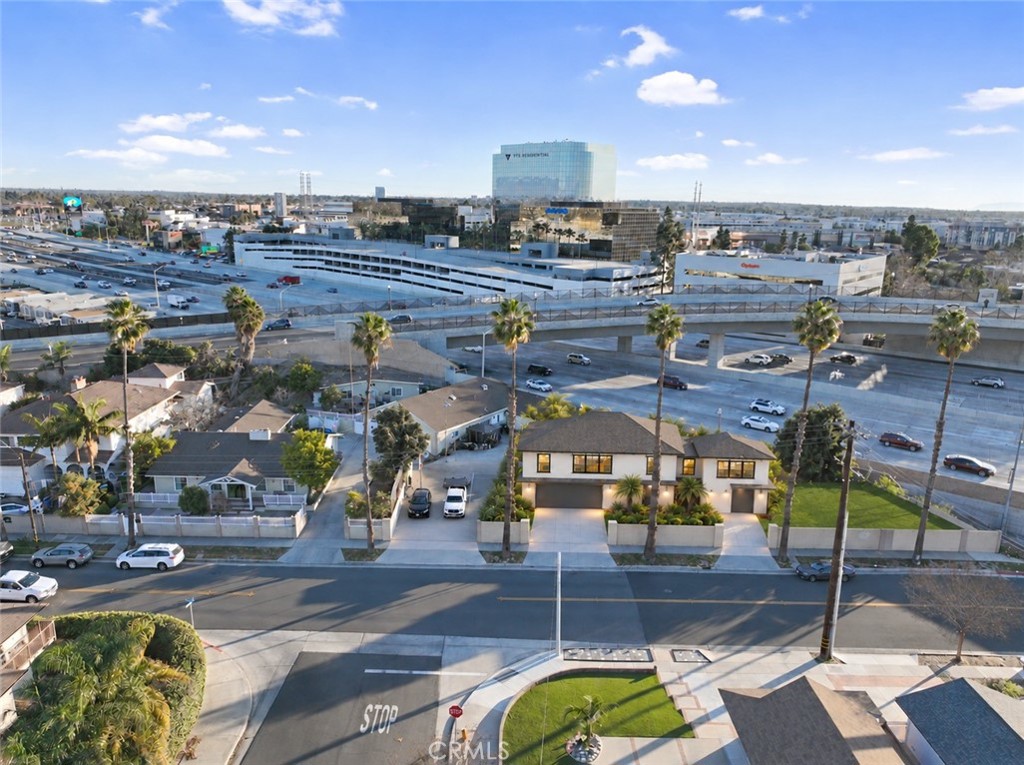
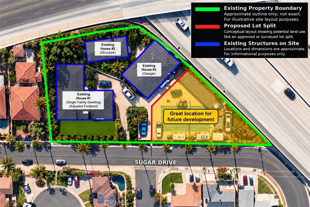
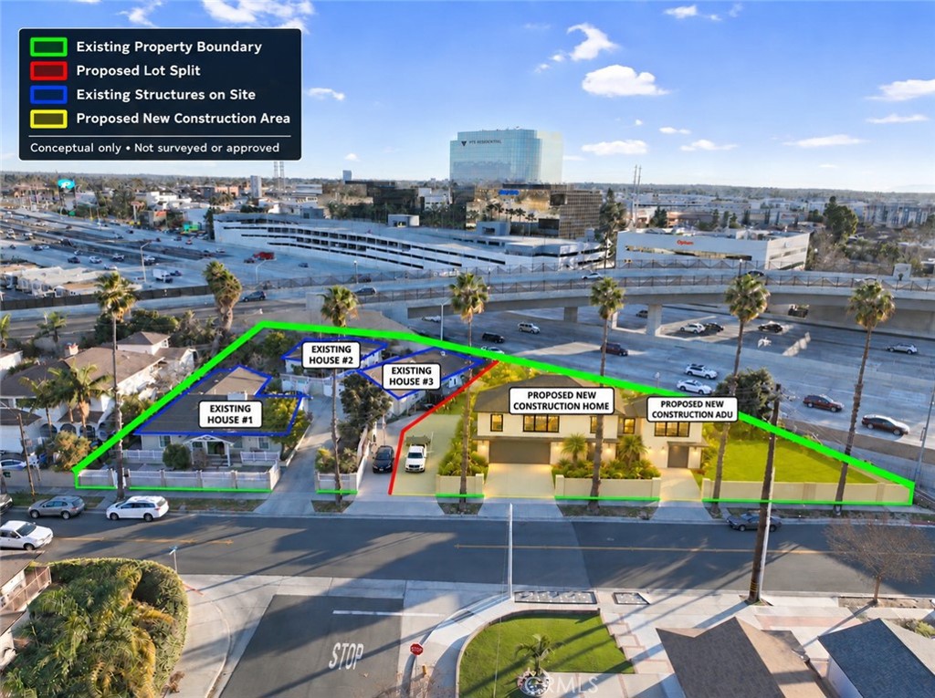
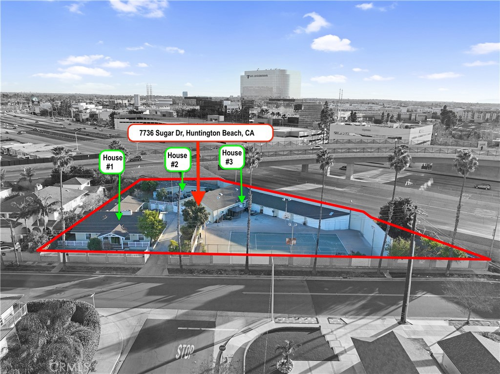
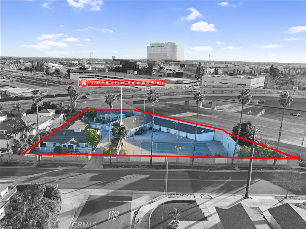
ONE PROPERTY. MULTIPLE STRATEGIES! This residential investment offers approximately 4,250 square feet of combined living space across three tenant-occupied residences, positioned along one portion of the lot. The remaining area, currently used in part as a tennis/basketball court, invites investigation of additional construction—potentially WITHOUT demolishing the existing income-producing improvements.
A COMPELLING HISTORY: According to the seller, the property operated as an elderly residential care facility for approximately 20 years. This may interest investors evaluating specialized residential operations, subject to verification of prior use, current licensing, zoning, building and fire requirements, and approvals. No care-facility license or authorization is represented as currently active or transferable.
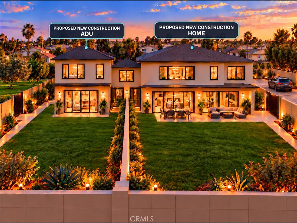
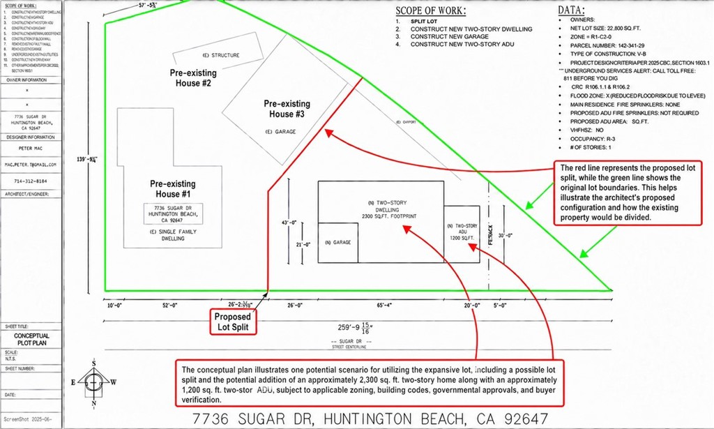
DEVELOPMENT POTENTIAL: Conceptual materials illustrate a possible approximately 2,300-square-foot, two-story new residence plus an approximately 1,200-square-foot, two-story ADU on the underutilized portion. A potential lot split may also be investigated. Explore creating additional value while retaining existing improvements and rental income!
EXISTING RESIDENCES: (1) Single-story 4-bedroom, 3-bath home with two primary suites and two fireplaces; (2) studio with kitchenette and full bath; and (3) 2-bedroom, 1-bath residence with kitchen area and living room. All are tenant-occupied on month-to-month agreements.
THE OPPORTUNITY: Hold for rental income, investigate residential development, or evaluate a specialized residential use based on the property’s history and configuration. Review the aerial photographs, conceptual plans and renderings.
IMPORTANT: This is a residential property, not represented as commercially zoned. Measurements are approximate. Plans are conceptual; construction, ADU size, subdivision, care operations, and rental continuity during construction are not approved or guaranteed. Buyer to verify legal unit status, zoning, permitted uses, licensing, tenant rights, access, utilities, easements, feasibility, costs and required approvals.
Photographs
Photos of 7736 Sugar Drive, Huntington Beach
Specifications
Property Details
At a glance
- Price
- $2,600,000
- Days On Site
- 201 Days
- Building Size (SqFt)
- 4,250 sqft
- Lot Size
- 0.52 Acres
- Year Built
- 1950
- MLS® Number
- IG26095464
- Status
- Active
Property Details
- Property Type
- Multi Family
- MLS Number
- IG26095464
- Building Size (sq ft)
- 4,250
- Lot Size (sq ft)
- 22,800
- Lot Size (acres)
- 0.5234
- Year Built
- 1950
- Units
- 3
- Occupancy
- Tenant
- Utilities
- Electricity Connected, Natural Gas Connected, Sewer Connected, Water Connected
- Parcel Number
- 14234129
- On Market Date
- 2026-05-02
Financials
- Net Operating Income
- $102,000
- Cap Rate
- 3.7%
- Operating Expenses
- $12,000
The record
Property History for 7736 Sugar Drive
| Date | Event | Price | Note |
|---|---|---|---|
| May 28, 2026 | Price reduced | $2,600,000 | From $2,700,000 |
| May 2, 2026 | Listed for sale | $2,600,000 |
No prior MLS sales on record for this property since 2012.
Added by Realatrends Real Estate
Flood, Fire and Earthquake Zones for 7736 Sugar Drive
We looked up this property's map point in public government maps. These facts are not part of the MLS listing.
Hazard zones
- Flood zone
Zone X. Outside FEMA's Special Flood Hazard Area.
FEMA National Flood Hazard Layer, FIRM panel 06059C0251J effective December 3, 2009. Checked November 16, 2026.
- Fire hazard severity zone
Not in a fire hazard severity zone on the State Fire Marshal's map.
CAL FIRE, State Fire Marshal map for Local Responsibility Areas, March 24, 2025. Checked November 15, 2026.
- Earthquake fault zone
Outside the Alquist-Priolo Earthquake Fault Zones.
California Geological Survey, Earthquake Fault Zones map, Newport Beach quadrangle, released July 1, 1986. Checked November 15, 2026.
- Liquefaction zone
Inside a Seismic Hazard Zone for liquefaction.
California Geological Survey, Seismic Hazard Zones map, Newport Beach quadrangle, released April 15, 1998. Checked November 15, 2026.
- Landslide zone
Outside the earthquake-induced landslide zones.
California Geological Survey, Seismic Hazard Zones map, Newport Beach quadrangle, released April 15, 1998. Checked November 15, 2026.
- Tsunami hazard area
Outside the Tsunami Hazard Area on the State's evacuation planning map.
California Geological Survey and Cal OES, Tsunami Hazard Area map for Orange County (2021). Checked November 15, 2026.
Internet and charging
- Fixed internet
Cable: Spectrum, up to 1,000 Mbps, at 4 of 4 residential locations in this census block. Fixed wireless: Cosmo Network Solutions, LLC, up to 350 Mbps, at 4 of 4. Fixed wireless: Verizon, up to 300 Mbps, at 1 of 4.
FCC National Broadband Map, provider-reported data as of June 30, 2026, for census block 060590997022016, not for this address. Not endorsed by the FCC. Checked October 15, 2026.
- EV charging
Nearest public charger 0.3 miles away (Tesla Destination, 6 Level 2 ports). 181 public charging ports within 3 miles.
U.S. Department of Energy, Alternative Fuels Data Center. Straight-line distance. Checked November 15, 2026.
These facts are for the listing's map point, which can sit off the lot. A zone line can also cross a lot, and agencies revise their maps. In cities, the fire zone line follows the State Fire Marshal's 2025 map; each city adopts its own map and may add areas. These lines are not a Natural Hazard Disclosure. Check the official maps and the seller's disclosures before you rely on them. Sources for the earthquake zone lines: Reproduced with permission, California Geological Survey, Webservice of Official Maps of Alquist-Priolo Earthquake Fault Zones (2025). Reproduced with permission, California Geological Survey, Webservice of Official Maps of Seismic Hazard Zones (2025).
Official maps
The neighborhood
About Huntington Beach
Huntington Beach stretches along the Pacific coast in Orange County, anchored by its landmark pier, the Bolsa Chica Ecological Reserve, and Huntington Central Park, the largest city-owned park in the county. Nicknamed Surf City USA, the community spans beachfront blocks, the waterways of Huntington Harbour, and inland neighborhoods within the Huntington Beach Union High School District.
Location
Location
Nearby listings
Similar Properties for Sale in Huntington Beach
Pending
Explore
Explore Huntington Beach Real Estate
See Orange County commercial property for sale, or search the full Orange County MLS on our live homes search. Questions about 7736 Sugar Drive? Talk to Realatrends.
- Huntington Beach Homes for Sale
- Huntington Beach 92647 Homes for Sale
- Huntington Harbour
- Orange County Real Estate
Explore Orange County
Browse Homes by City
Listed by Benjamin Rubalcava of Re/Max Partners
Listing information updated Nov 1, 2026 at 7:25 PM PT. Source: CRMLS.
 This information is for your personal, non-commercial use and may not be used for any purpose other than to identify prospective properties you may be interested in purchasing. The display of MLS data is usually deemed reliable but is NOT guaranteed accurate by the MLS. Buyers are responsible for verifying the accuracy of all information and should investigate the data themselves or retain appropriate professionals. Information from sources other than the Listing Agent may have been included in the MLS data. Unless otherwise specified in writing, the Broker/Agent has not and will not verify any information obtained from other sources. The Broker/Agent providing the information contained herein may or may not have been the Listing and/or Selling Agent.